


HIKING IN
WASHINGTON’S NATIONAL PARKS
Mt. Rainier and Olympic
August 14-28, 2010
ITINERARY
Day 1 - Saturday, August 14 – Fly from home cities. Independently take free shuttle to our motel – Sleep In Sea Tac, 20406 International Blvd , SeaTac, WA, US, 98198 Phone: (206) 878-3600
Washington Olympic Peninsula Day Hikes
You can read about the Olympic hikes in “Day Hike! Olympic Peninsula” by Seabury Blair, Jr.
Day 2 - Sunday, August 15 - Drive from Sea Tac area to Port Angeles. Visit Port Townsend along the way. Short hike in Port Townsend. Visit Hurricane Ridge Visitors’ Center in Port Angeles. Check into Downtown Hotel, Port Angeles, WA 866-688-8600. Explore Port Angeles.
(B, D) Downtown Hotel
Day 3 - Monday, August 16 – Hike #36, Hurricane Hill, page 113, 6 mi. RT, 3 hours, 1700’, high point 5757’. Climb along a paved nature walk 1.6 miles to the site where an aircraft spotter’s cabin once stood, then follow a trail along a rocky open ridge to a mountain view overlooking the Elwha River valley and Lake Mills, far below.
OR
For those who would like a longer hike, we will offer the Hike #34, Klahhane Ridge (pg. 107, 4.6 mi RT, 2 ½ hours, 2,050’, high point 6046’, difficult rating. This hike has all the scenery and views of 5 star 12.9 mile Heather Park – Lake Angeles Loop.
We will then climb Hurricane Hill 3 mi RT with 700’ elev gain to the eye ball whooping top. If anyone still has energy at the top we will proceed along the ridge for another 3 mi. RT.
Downtown Hotel
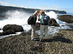
Day 4 - Tuesday, August 17 – Hike #61, Hole-in-the-Wall (Rialto Beach) page 192, 5 mi. RT, 2.5 hours, 80’, high point 80’. This beach walk follows smooth sand all the way to a big rocky headland that can be passed at low tide by walking through a natural tunnel carved by the surf. Trailhead is 68 miles from Port Angeles near La Push. Rialto Beach..
OR
Hike #60-, Cape Alava Loop, page 189, 9.3 miles RT, 5 hours, 140’ gain, 180’ high point. The Cape Alava Loop is probably the finest wild Pacific Coast day hike that you will find in the Lower 48. Follow a plank trail to the ocean, 3.3 miles away from trailhead. Walk the beach for 3 miles. You may wish to visit the site of an ancient Makah Indian village 0.5 miles to the north, an important archaeological site. Once back on the beach, you will walk a mile south to Wedding Rocks, where you will find petroglyphs on two groups of rocks above the high-tide line. High tides here and south, at 4.8 miles, could force you up and over the headlands via interesting “sand ladders.”
Once past the second headland, you will walk sandy beach south to Sand Point, 6.3 miles from the trailhead. From here it is 3 miles back to the trailhead via a plank pathway.
Downtown Hotel
Day 5 - Wednesday, August 18 – Take ferry to Victoria, British Columbia, Canada. Be sure to pack your passport. Back to Port Angeles at around 7:30pm. Downtown Hotel
Washington – Mt. Rainier Hikes
You can read about the Mt. Rainier hikes in “Day Hike! Mount Rainier” by Ron C. Judd
Day 6 - Thursday, August 19 – Time to move on to the Nisqually Lodge, 31609 State Route 706 E., Ashton, WA 98304 (360)569-8804 . This is at the southern section of the park. Nisqually Lodge.
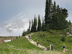
Day 7 - Friday, August 20 - Part 1 - #14, page 55, Panorama Point/Skyline Loop, 5.5 mile loop, 4 hours, 1700’. High point 7100’. One of the highest maintained trails in the park, this challenging, stunning, high-altitude loop whisks you to – and above – all of the best scenery at Paradise. It’s an annual rite of passage for many Tahoma lovers.
For those who would like a longer hike….you can connect with the Alta Vista Trail.
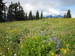
Part 2 - #13, page 51, Alta Vista, 1.6 mi RT, 1 hour, 540’. High point 5950’. A short, sweet, fairly steep ascent to one of the area’s premium wildflower-meadow vistas.
(B) Nisqually Lodge
Day 8 - Saturday, August 21 – #6, page 23, Comet Falls/Van Trump Park, 3.8 miles RT to Comet Falls view/6.0 miles RT to Van Trump Park viewpoint, 2.0 hours/3.5 to 4.0 hours, 1600’/2200’. High points 5200’/5800’. Make a short, steep climb to one of the park’s most popular hiking destinations – 320-foot Comet Falls – with the option of going on to the splendid Van Trump Park or even farther to Mildred Point, and alpine viewpoint.
(B) Nisqually Lodge
Day 9 - Sunday, August 22 - The two hikes share a parking lot.
Part 1 - #20, page 80, Pinnacle Saddle 2.6 miles RT, 2 hours, 1055’. High point 5920’. On clear days, this is a delightful, view-rich ascent from Reflection Lakes. Climb through sub-alpine forest into open, rocky terrain to a grand vista of Rainier from the saddle between Pinnacle and Plummer Peaks, two crown jewels of the Tatoosh Range.
Part 2 - #19, page 77, High Lakes Loop, 3 mile loop, 2 hours, 600’. High point 5500’. A short, pleasant, moderate loop with great views, ample wildflowers, and abundant wildlife takes you by the shores of gorgeous alpine lakes.
OR - Combination of trails…go from one to the other.
(B) Nisqually Lodge
Day 10 - Monday, August 23 – We move on to Crystal Mounatain and the Sunrise area of the Mt. Rainier National Park. We will stay the area of Crystal Mountain (outside the park)in Enamclaw, WA. Along the way, we will explore Stevens Canyon area of the Mt. Rainier NP.
Combine two easy hikes.
The route that we take to combine the two hikes = 5.5 miles RT
Part 1 - #25, page 99, Silver Falls Loop, 3 mile loop, 1.5 hours, 330’. High point 2200’, Take an easy walk from Ohanapecosh Campground to Silver Falls, one of the park’s most impressive lower-altitude sights.
Part 2 - #24, page 95, Grove of the Patriarchs, 1.25 mile RT, 1 hour, 0’. High point 2200’. This is a very easy, memorable walk through a splendid old-growth forest on an island in the middle of the beautiful Ohanapechosh River. Isolated on the island and thus protected from fire, the trees have grown to gigantic proportions. In this small area are 20 western red cedars more than 25 feet in circumference; among them is the largest cedar in the Park. There are ten Douglas-firs over 25 feet in circumference; one is 35 feet. The trees are estimated to be nearly 1000 years old. Name of Lodging TBA (B)
.
Day 11 - Tuesday, August 24 – We will take our first hike “Bullion Basin Loop” 6.4 mile loop, 4 hours. High Point 6,300’, Elevation Gain: 1,600’. This trail leads through steep, flower-filled alpine meadows, over narrow ridge spines, and under shady forest canopies. Views sweep over the dry, pine valleys of the eastern Cascades, the glacier-covered summit of massive Mount Rainier, and the craggy peaks of the central William O. Douglas Wilderness Aea to the south. Best of all, despite the modest level of difficulty (not too long, not too steep), the trail isn’t heavily used, so its possible to find a quite place for a peaceful lunch high on the ridge.
OR
Emmons Moraine/Glacier Basin. Page 134. 4.0 miles round-trip to end of Emmons Moraine/6.2 miles round-trip to Glacier Basin. Elevation Gain 850’ / 1650’. Hike a river valley to dueling payoffs: a high vista over the massive Emmons Glacier and a great alpine basin in a park area once home to mining activity. This hike can be extended. Name of Lodging TBA.
Day 12 - Wednesday, August 25 – Burroughs Mountain – 6.2 miles out and back OR 6.7 mile loop via Sunrise Camp. 1000' elevation gain. Page 158 . One of the most spectacular alpine day hikes from Sunrise, the Burroughs Mountain Trail is a fairly strenuous climb along the top of Burroughs Mountain in a bizarre, tundra-like environment with incredible views throughout. Add approximately another mile to get to Burroughs Second Summit for a spectacular and closer view of the mountain. For anyone still up for more the trail does continue further over grassy knolls for a yet closer encounter with this majestic mountain.
OR – from same trailhead
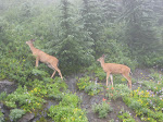
Frozen Lake/Mount Freemont Lookout – 5.4 miles round trip, Elevation gain 781', High Point: 7181'. Page 154. Enjoy a memorable walk along Sourdough Ridge to a five-way trail junction near Frozen Lake, and beyond to a mountain look out tower where mountain goats and other wildlife often linger.
OR – from same trailhead
Sunrise Rim. 4.9 mile loop. 840' Elevation Gain. Loop trail that showcases gorgeous wildflower meadows, mountain views, and plentiful wildlife.
Name of Lodging TBA
Day 13 - Thursday, August 26 – Summerland. Page 131. 8.4 miles round-trip, 2,140’ elevation gain.. High point 5,950’. A memorable – and often crowded – stroll take you through several miles of forest lands along Fryingpan Creek, and the steeply up for a final mile to picturesque Summerland Camp, on of the park’s most famous subalpine destinations.
OR – one of the easier hikes listed above
Group dinner.
Name of Lodging TBA (D)
Day 14 – Friday, August 27 – Check out of hotel after breakfast. Drive from Crystal Mountain to Sea Tac. Check into Sleep Inn – Sea Tac Airport. You have the option of taking a shuttle into Seattle for sightseeing.
Day 15 - Saturday, August 28 – Depart for home cities. Free shuttles from our motel to the airport. (B)
Subscribe to:
Post Comments (Atom)
No comments:
Post a Comment